
What Makes The Indian Himalaya So Distinct
The Himalaya mountains in India cover the most geographically and culturally varied section of a range that stretches across five countries. Across roughly 2,500km and seven states, the Indian Himalaya shifts from the cold desert of Ladakh to the monsoon-drenched forests of Arunachal Pradesh, with different languages, religions, cuisines and building traditions in each region.
What makes the Indian Himalaya remarkable is how distinct each region is from the next. A week in Spiti and a week in Sikkim share almost nothing in common beyond altitude. The Indian Himalaya is best understood as several distinct mountain regions that happen to sit within the same country, and that is what makes it worth looking at closely.
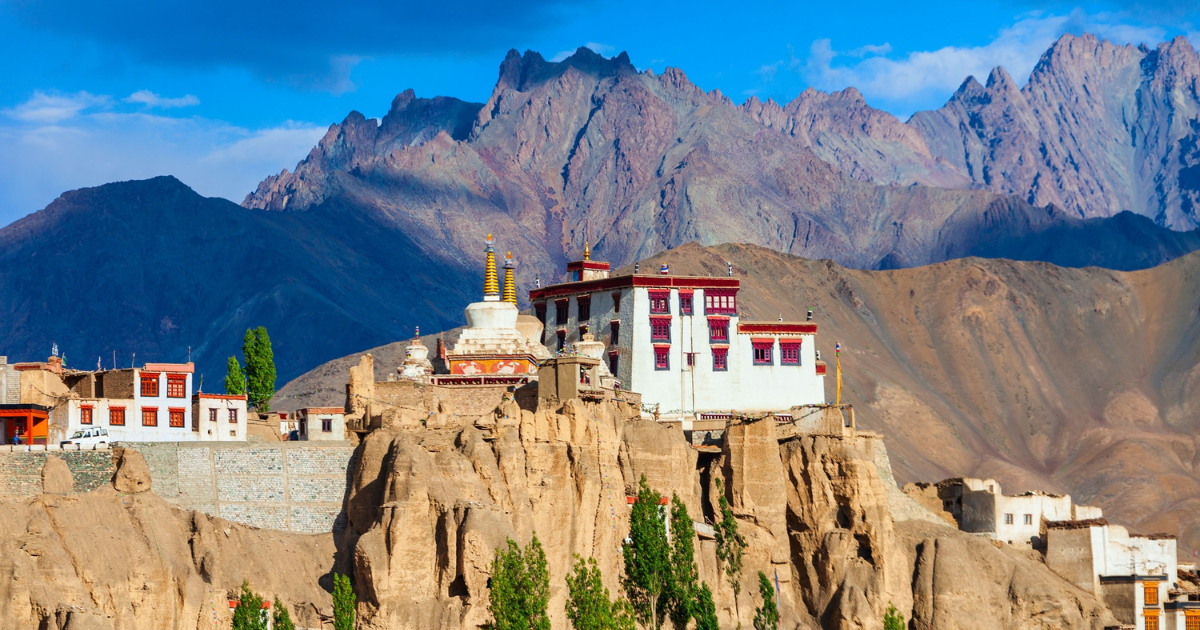
Lamayuru is one of the oldest monasteries in Ladakh, built into the same eroded landscape it overlooks.
What makes the Indian Himalayas unique?
Most Himalayan countries offer one type of mountain experience. Nepal is defined by its trekking culture, Bhutan by a single Buddhist identity across a compact landscape, and the Tibetan Plateau by high-altitude remoteness with restricted acc\ess. The Indian Himalayan ranges cover all of these and more within a single border.
A range of three mountain bands
India is one of the few Himalayan countries that contains all three parallel bands of the mountain system. The Shivalik hills form the lowest range, rising from the plains into subtropical foothills covered in sal forest and grassland. Behind them sits the Greater Himalaya, home to the highest peaks, deep valleys and alpine meadows.
Further north again, the Trans-Himalaya crosses into high-altitude plateau country, where the landscape resembles Tibet more than anything south of the main range. Having all three bands within a single country gives travellers access to dramatically different terrain without crossing an international boundary.
The only Himalayan region with a long domestic tourism history
Indian travellers have been visiting these mountains long before international tourism reached the region. Pilgrimage routes through Uttarakhand and Himachal Pradesh go back centuries, while hill stations like Shimla and Darjeeling have drawn Indian holidaymakers since the colonial period. That domestic demand shaped the infrastructure.
Roads, accommodation and transport networks grew to serve Indian travellers rather than international trekking groups, which is what happened in Nepal and Bhutan. For visitors, the difference is noticeable. There is a wider spread of accommodation, more frequent transport, and a food and hospitality culture that developed organically over generations rather than being built around a foreign market.
Accessibility without expedition planning
Most of the Indian Himalaya is reachable through a well-developed domestic network. Flights connect major cities to regional hubs like Leh, Kullu, Dehradun and Bagdogra, and road networks, though sometimes slow, reach most major valleys and towns.
Accommodation ranges from basic guesthouses to well-run heritage properties, and local transport options exist even in remote districts. This level of accessibility is unusual for a high-altitude mountain system and sets the Himalaya mountains in India apart from regions like western Tibet or upper Mustang in Nepal, where logistics require specialist planning.
Cultural diversity across the range
The Himalaya mountains in India contain at least five major cultural zones, each shaped by geography and centuries of relative isolation. Uttarakhand is defined by Hindu pilgrimage, with temple towns and sacred rivers running through its valleys. Ladakh and Sikkim follow Tibetan Buddhist traditions, with monasteries built into cliff faces and prayer flags strung across mountain passes.
Arunachal Pradesh is home to dozens of tribal groups, many practising animist traditions that predate both Hinduism and Buddhism in the region. Himachal Pradesh carries Sikh and Hindu heritage in its lower valleys while its upper reaches, particularly Spiti, are culturally Tibetan. These traditions developed independently because the mountains between them made regular contact difficult, thereby preserving identities that remain distinct today.
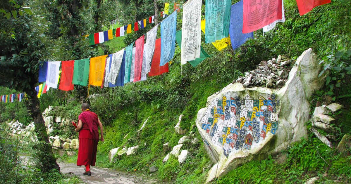
Tibetan Buddhist traditions are a visible part of daily life across several Indian Himalayan states.
Which states are part of the Indian Himalaya?
The Himalayan ranges in India enter from the northwest in Jammu and Kashmir and run east through Himachal Pradesh, Uttarakhand, Sikkim and into Arunachal Pradesh. The corridor covers roughly a third of the total length of the Himalaya and passes through more climatic and cultural zones than any other national section of the range.
The western Himalaya
The western stretch takes in Ladakh, Kashmir, Spiti and Kinnaur. This is the driest and most sparsely populated part of the Indian Himalaya, with much of the landscape sitting above 3,500m. Ladakh and Spiti share strong cultural ties with Tibet, visible in their monasteries, prayer flags and flat-roofed mud brick architecture.
Kashmir sits lower, with its broad river valley, walnut groves and houseboats on Dal Lake offering a completely different character. The western Himalaya draws travellers looking for high passes, stark terrain and Buddhist heritage.
The central Himalaya
Uttarakhand occupies the central section, split between the Garhwal region to the west and Kumaon to the east. Garhwal is the spiritual heart of the Indian Himalaya, home to the Char Dham pilgrimage circuit and the source of the Ganges at Gaumukh glacier.
Kumaon is quieter, with oak and rhododendron forests, colonial-era hill stations like Nainital and a landscape that feels more pastoral than dramatic. The central Himalaya is also where some of India's best-known treks sit, including the Valley of Flowers and Roopkund.
The eastern Himalaya
Sikkim, Darjeeling and Arunachal Pradesh make up the eastern end of the Indian Himalaya, and the change in character is immediate. Rainfall here is significantly higher, which means denser forests, richer biodiversity and a greener, more tropical feel at lower altitudes.
Sikkim is dominated by Kanchenjunga, the third highest peak in the world, and its monastery culture reflects close ties to both Tibet and Bhutan. Arunachal Pradesh is the least visited of all Indian Himalayan states, with landscapes that range from subtropical lowland forest to snow-covered passes along the Tibetan border.
What you can experience across the Indian Himalayas?
Travelling through the Indian Himalaya can change character completely within a single journey. A route that begins in a green valley town might cross a 5,000m pass by midday and arrive at a centuries-old monastery by evening. Few mountain regions in the world pack that kind of range into such a compact area.
Hill stations and valley towns
Most journeys into the Indian Himalaya begin in a hill station or valley town. Shimla, Darjeeling, Mussoorie and Gangtok all started as colonial-era retreats, but each has taken on its own identity since. Shimla still carries its British summer capital history in its ridge promenade and mock-Tudor buildings.
Darjeeling is inseparable from its tea estates and its early morning views of Kanchenjunga. Gangtok feels more modern and compact, a working regional capital that doubles as the starting point for most journeys into higher Sikkim. These towns are a comfortable starting point before heading toward some of the best places in the Indian Himalayas deeper in the mountains.
River systems and gorges
The routes out of these towns almost always follow a river. The Ganges starts at Gaumukh glacier in Uttarakhand and cuts through deep gorges before flattening out at Rishikesh. The Indus runs the length of the Ladakh valley, and most travellers to the region follow it without realising.
The Teesta carves through Sikkim between steep forested ridges, while the Brahmaputra enters India from Tibet through Arunachal Pradesh, passing through some of the deepest gorges on earth. Following these rivers upstream is how most travellers move from the foothills into the higher Himalayan ranges, and the landscape transforms steadily as the valleys narrow and the altitude climbs.
National parks and wildlife
Running through all of these zones, the Indian Himalaya contains a chain of protected areas that cover an unusual range of altitudes and climates. Great Himalayan National Park in Himachal Pradesh sits within dense temperate forest with restricted access, keeping it one of the quieter reserves in the country.
Khangchendzonga National Park in Sikkim spans from 1,800m to over 8,500m, meaning its lower slopes are subtropical broadleaf and its upper reaches are permanent ice. The Valley of Flowers in Uttarakhand opens briefly between July and September, covering alpine meadows with over 600 species of wildflower. Each park protects a different type of habitat across the Himalayan ranges, and together they form one of the most varied conservation corridors in Asia.
High-altitude passes and monasteries
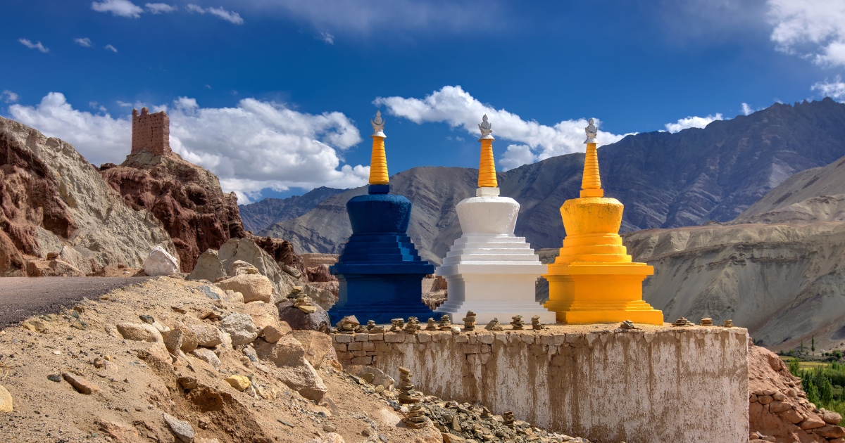
Above the river valleys, the roads climb toward some of the highest motorable passes in the world. Khardung La and Chang La in Ladakh sit above 5,000m, and driving across them is an experience in itself. The landscape shifts abruptly, opening into wide barren plateaus on one side and dropping into tight gorges on the other. Colourful chortens mark the roadsides between passes, a constant reminder that these routes have been used for centuries.
The monasteries in these regions were built in places chosen for their remoteness. Hemis and Thiksey in Ladakh, Key Monastery in Spiti, all perched on ridgelines or cliff edges where silence and exposure were considered part of the spiritual purpose. Modern roads have made them more accessible, though reaching most of them still takes commitment.
Buddhist chortens line the roadsides between passes in Ladakh, marking routes that have been used for centuries.
Which part of the Himalayas is best in India?
The Indian Himalaya is so varied that asking which part is best is a bit like asking which season is best in a year. Ladakh's high desert, Sikkim's monsoon forests and Uttarakhand's pilgrimage valleys are so different from each other that they barely feel like the same mountain range. The answer comes down to what a traveller wants to experience.
What is the best part of the Indian Himalayas for landscapes?
Ladakh and Spiti stand out for sheer visual impact. Both sit in the rain shadow of the Greater Himalaya, which means dry air, wide open valleys and an almost constant clarity of light. The terrain is stark and mineral, with colours shifting between ochre, grey and deep red depending on the rock formations.
Pangong Lake in Ladakh sits at 4,350m and changes colour through the day as the light moves across it. Spiti's Pin Valley feels similarly remote, with the river cutting through a narrow gorge flanked by near-vertical cliff walls. These are among the best places in the Indian Himalayas for travellers who prefer emptiness and scale over any single landmark.
Where to see wildlife in the Indian Himalayas?
The eastern Himalaya holds the greatest concentration of biodiversity. Sikkim's forests support red pandas, and the higher reaches of Khangchendzonga National Park are snow leopard territory, though sightings require patience and altitude. In Uttarakhand, the Valley of Flowers opens briefly between July and September with over 600 species of wildflower across its alpine meadows.
Great Himalayan National Park in Himachal Pradesh is one of the more rewarding options for birdwatchers, with the Himalayan monal and western tragopan both present in its upper forests. The Indian Himalaya is a series of distinct habitats spread across different altitudes and climates, and the best wildlife experiences depend on which species and ecosystems a traveller is most interested in.
What are the best treks in the Indian Himalayas?
Himachal Pradesh and Uttarakhand offer the most accessible trekking, with well-established routes that range from moderate valley walks to serious high-altitude crossings. Hampta Pass in Himachal takes trekkers from the green Kullu Valley over a 4,270m pass into the dry landscape of Lahaul, covering two completely different ecosystems in a few days.
The Markha Valley trek in Ladakh is longer and more demanding, following a remote river valley past small villages and monasteries. Each of these routes gives a different sense of the Indian Himalaya, and the best choice depends on fitness, season and which type of landscape a traveller wants to walk through.
Where to experience local culture in the Indian Himalayas?
Ladakh is the strongest option for travellers interested in Buddhist heritage. Its monasteries are active religious centres rather than museums, with daily prayer ceremonies, annual festivals and resident monastic communities. Hemis Festival in late June or early July draws large crowds for its masked cham dances, and smaller monasteries like Lamayuru and Alchi offer quieter, more intimate visits.
In Uttarakhand, the temple towns along the Char Dham route offer a direct window into Hindu mountain traditions that have largely remained unchanged for centuries. Arunachal Pradesh is the least accessible but arguably the most culturally distinctive, with tribal communities whose festivals, clothing and traditions have developed in relative isolation from the rest of the subcontinent.
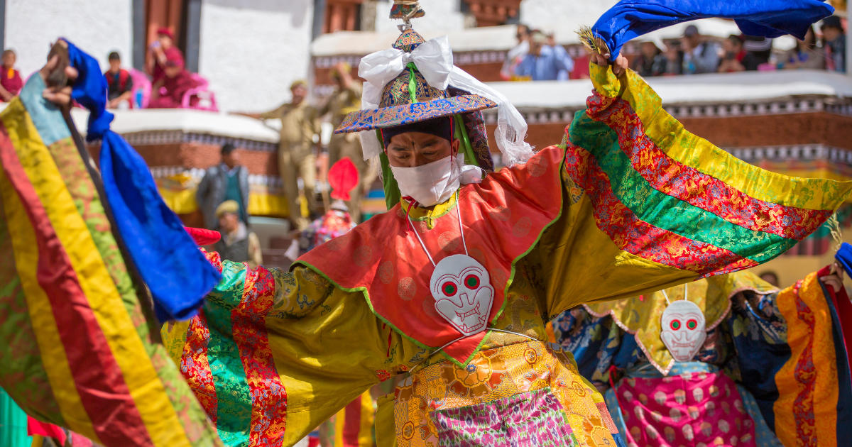
Hemis Festival draws large crowds each year for its masked cham dances, performed in the monastery courtyard in late June or early July.
Is the Indian Himalaya safe?
Yes. The Himalaya mountains in India are well-travelled by millions of domestic and international visitors each year, and the main considerations are environmental rather than personal. Altitude sickness can affect anyone above 4,000m, particularly in Ladakh, Spiti and upper Sikkim, and the standard advice is to allow time to acclimatise before going higher.
How to visit the Indian Himalayas?
The Himalaya mountains in India are more accessible than most people expect. Domestic flights connect major Indian cities to regional mountain hubs, and from there the journey continues by road into whichever region suits the itinerary. The main things to plan around are seasonality, drive times and permits for border areas.
When is the best time to visit the Indian Himalayas?
The Indian Himalaya does not have a single best season because the climate varies so much across the range. Ladakh and Spiti are best visited between June and September, when the high passes are open and the weather is dry and warm by local standards. This is also peak monsoon season for the rest of India, but these regions sit in a rain shadow and receive very little rainfall.
Uttarakhand and Himachal Pradesh are most comfortable in spring (March to May) and autumn (September to November), when the skies are clear and temperatures are mild at mid-altitudes. Sikkim and Darjeeling are best in spring or late autumn, as the monsoon hits the eastern Himalaya harder than anywhere else in the range.
How do you get to the Indian Himalayas?
Most regions of the Indian Himalaya are accessible through domestic flights into regional hubs. Leh serves Ladakh, Kullu covers the Manali and Spiti corridor, Dehradun is the gateway to Uttarakhand, and Bagdogra connects to Darjeeling, Sikkim and the eastern Himalaya. From these airports, the journey continues by road, and in several cases the drive itself is a significant part of the experience.
The road from Manali to Leh takes two days and crosses some of the highest passes in the country. The climb from Bagdogra to Gangtok takes around four hours through tea gardens and thickening forest. Some of the best places in the Indian Himalayas are a full day's drive or more from the nearest airport, which is worth factoring into any itinerary.
Do you need permits for the Indian Himalayas?
Three areas of the Indian Himalaya require permits. Arunachal Pradesh requires an Inner Line Permit for all Indian and international visitors, which must be arranged before arrival. Parts of Sikkim near the Tibetan and Bhutanese borders, including Nathula Pass and the Gurudongmar Lake area, require Protected Area Permits issued through registered tour operators.
In Ladakh, the Nubra Valley, Pangong Lake and several border areas also need permits that can be arranged in Leh, usually within a day. None of these processes are difficult, but they do require advance planning.
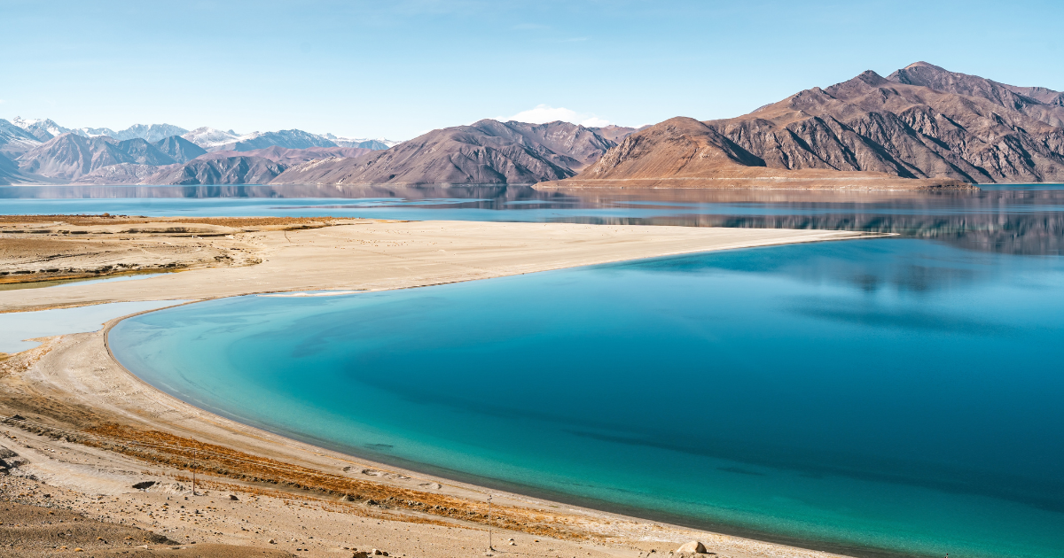
Pangong Lake sits at 4,350m in eastern Ladakh, reached via Chang La pass, and changes colour through the day as the light shifts across it.
Exploring the Indian Himalaya with Remarkable East
The Indian Himalaya covers so much ground that seeing it properly takes time, local knowledge and a well-planned route. The distances between regions are long and the seasons dictate which areas are accessible. Cultural shifts between states are significant enough that local knowledge makes a real difference to what you see and how you experience it.
Remarkable East runs small group tours through the region with a maximum of 12 guests per departure, each led by an expert host who knows the landscape, culture and logistics of the areas they travel through. Our India Walking Tour covers the hills of Sikkim and West Bengal on foot, moving through village paths, monasteries, tea estates and farmstays across 15 days.