
The Hidden Ridge Of Tarey Bhir In Sikkim
The hills of South Sikkim rise above the Teesta and Rangeet rivers, whose confluence marks part of the boundary with West Bengal. Namchi sits in the hills above these valleys, with roads leading out to smaller settlements such as Sadam. Here, the land narrows into Tarey Bhir, a cliff ridge with a walking path along its crest.
The path gives visitors a vantage point over both sides of the state boundary. Below lies the meeting of the rivers, while across the valley are the hills of Darjeeling and Kalimpong. Stone paving and steps follow the ridge towards the viewpoint, bringing visitors alongside the steep drop that gives Tarey Bhir its name. In Nepali, bhir means cliff.
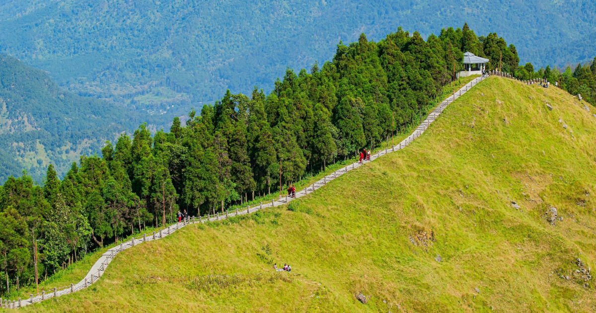
A little beyond Namchi’s main pilgrimage sites, Tarey Bhir offers a quieter walk along one of South Sikkim’s most distinctive ridges.
What is Tarey Bhir?
Tarey Bhir is a natural ridge stretching roughly 3km, with a cliff face dropping around 1,000 metres along one side. A paved walkway follows part of this formation, giving visitors the chance to explore its contours on foot. Stone steps follow the changing height of the crest, linking stretches of path along the ridge.
Walking here gives a sense of the scale that photographs can struggle to convey. The narrow path sits high above the wooded slopes, with views extending across the river valleys to the neighbouring hills. Visitors can stop along the way to take photographs and look across the landscape before continuing towards the viewpoint.
How long is the Tarey Bhir walk?
The Tarey Bhir walk takes approximately one to two hours for a return trip, including stops at the viewpoints. The paved path follows part of the roughly 3km ridge, descending by stone steps towards views of the Teesta and Rangeet confluence. The time needed depends on how far visitors follow the ridge and how long they spend overlooking the valley.
Concrete benches line the stepped route, with umbrella-shaped shelters covering some of the seating areas. These provide places to pause during the descent and return climb. Visitors retrace the same path to the entrance, with the uphill stretch generally taking longer. The route also allows for a shorter visit, as walkers can turn back before completing the descent.
What can you see from Tarey Bhir Point?
The main viewpoint at Tarey Bhir overlooks the Teesta and Rangeet confluence, with the Darjeeling and Kalimpong hills beyond. The outlook takes in the river channels far below, settlements across the valley and the vegetation growing beside the ridge.
The confluence of the Teesta and Rangeet rivers
The Teesta and Rangeet are Sikkim’s two main rivers, and their meeting point is visible from the walkway. The Teesta flows south from the northern mountains, while the Rangeet approaches from the west after draining the western hills. They join at Triveni and continue towards the plains of West Bengal under the Teesta name.
Their meeting also has a place in Lepcha oral tradition. One folktale describes the rivers as lovers who take separate routes through the mountains, guided by a snake and a bird. After a race and a quarrel, they reconcile and flow onwards together. The story is recalled in Lepcha marriage traditions, where their eventual union represents a lasting partnership.
Views of the Darjeeling hills and Kalimpong
The view across the valley opens towards the Darjeeling and Kalimpong hills in West Bengal, with the Teesta winding between them below. Kalimpong town sits high above the river on the eastern side, its buildings spread along the ridges and slopes. From Tarey Bhir, the town appears as part of the wider mountain landscape rather than as a separate urban centre, with wooded hills dropping away towards the water.
On the opposite side, the tea gardens around Peshok add a different pattern to the view. Neat bands of cultivated tea break up the darker forest, while roads and scattered houses mark the surrounding slopes. The gardens occupy the lower slopes above the Teesta, with forest continuing along the steeper ground towards the ridgeline.
Forest and vegetation along the ridge
Pine trees cover parts of the hillside beside the route, while grass, moss and low shrubs occupy more open ground. The vegetation changes over short distances, with wooded stretches giving way to exposed sections near the cliff edge. These smaller features remain visible close to the path even when clouds obscure the distant landmarks.
The lower valleys around the Teesta and Rangeet are warmer than the high mountain slopes, and their forests reflect that change. Sal and other broadleaved trees fill the lower elevations, creating a denser, more varied canopy than the pine-covered sections near the ridge. As the seasons change, the trees shed and renew their leaves, altering the colour and texture of the hillsides below.
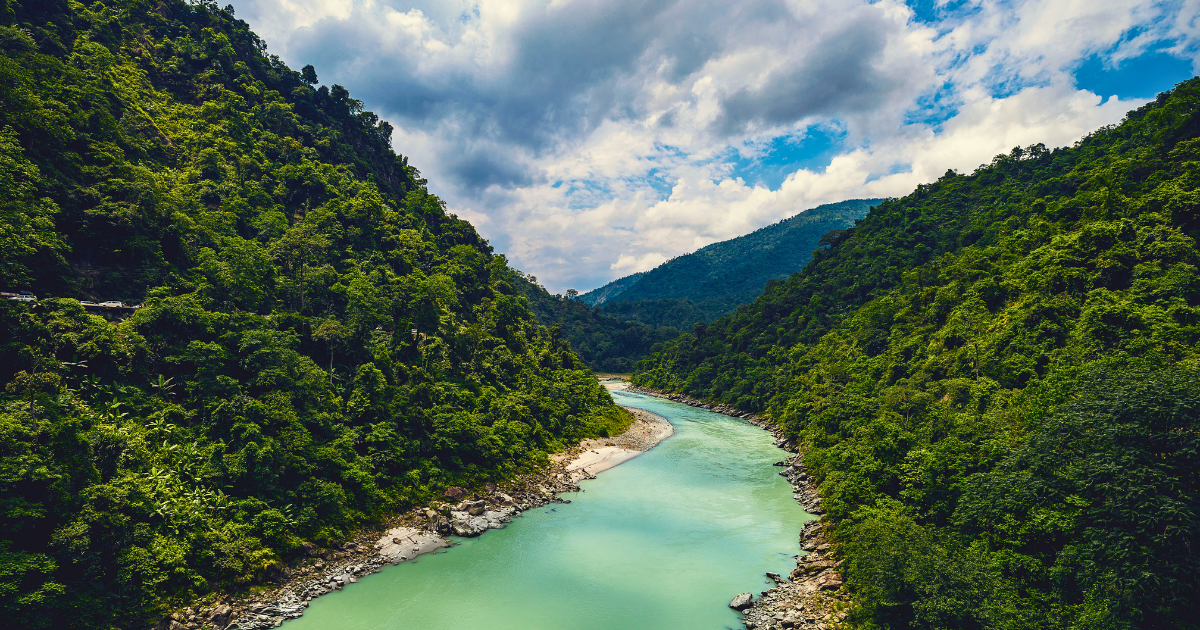
The ridge looks towards the Teesta valley, where the river cuts through the forested hills below South Sikkim.
What to know before visiting Tarey Bhir
The paved walkway is straightforward to visit for most travellers, but the timing of the trip and a few practical details can make a significant differencee. The ridge is exposed, the elevation is higher than Namchi itself, and the return climb is steeper than most people expect. A little planning before setting off makes the walk more comfortable and increases the chances of clear views from the far end.
When is the best time to visit Tarey Bhir?
October and November are particularly rewarding months for the walk because the post-monsoon air often leaves the distant ridges more clearly defined. After the summer monsoon, the surrounding forests retain their greenery, while the retreating rains generally bring better opportunities to see across to Darjeeling and Kalimpong. Cooler temperatures also make the climb back more comfortable.
March to May offers another good visiting period, with warmer days as spring progresses. Showers become more frequent towards summer, so this season does not guarantee dry conditions. These changes become more pronounced during the monsoon, when cloud can settle over the valley and rain can leave the paving slippery. By winter, the rain has eased, but colder mornings make an additional warm layer useful on the exposed sections.
Is Tarey Bhir suitable for families and older travellers?
The route to Tarey Bhir follows a paved walkway and a long flight of steps down the ridge. The descent is manageable for visitors who are comfortable walking downhill, but the return journey requires a steady climb back to the viewpoint. The walk is therefore best judged by how comfortably visitors can manage repeated stairs and changes in elevation.
Families can adjust the outing by turning back before reaching the lower sections, while older travellers may prefer to take the descent slowly and use the benches along the route for breaks. This flexibility does not remove the need for care, however. Children need close supervision near the cliff edge, even where railings are present, and the stepped route makes Tarey Bhir unsuitable for wheelchairs and pushchairs.
What should visitors bring and wear for the Tarey Bhir walk?
The stone surface calls for shoes with a secure fit and good grip, especially after rain. Clothing needs to suit both the effort of climbing and the cooler pauses along the crest. Light layers and a windproof jacket make it easier to adjust between the two, with extra warmth useful during winter.
Water and a small snack are worth bringing from Namchi or the accommodation before setting out. Seasonal stalls may sell steamed dumplings known as momos, noodles and other refreshments near the attraction, but their availability varies. Carrying supplies in a small backpack leaves hands free for the railings and keeps them accessible during breaks.
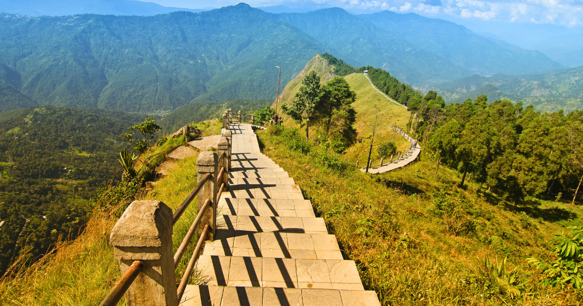
The stone walkway is clear and well maintained, but the exposed ridge and steady return climb make good shoes and water useful.
How to reach Tarey Bhir
Tarey Bhir is reached by road through the Sadam area, with Namchi providing a convenient base for the visit. Travellers arriving from outside Sikkim can continue into the hills from Bagdogra Airport or New Jalpaiguri railway station, both near Siliguri in West Bengal.
From Namchi to Tarey Bhir
Tarey Bhir lies approximately 16km by road from Namchi. A hired car or local taxi can take visitors towards Sadam and the entrance to the walkway, where the journey continues on foot.
For a return outing, arranging for the driver to wait allows time for the ridge walk without needing to find another vehicle afterwards. The visit can also be included in a day exploring the countryside around Namchi, with the walking time agreed before setting out.
Arriving in Sikkim from outside the state
Bagdogra Airport is approximately 102km from Namchi, while New Jalpaiguri railway station is around 96km away. Both serve as arrival points for journeys into southern Sikkim, with onward travel by road. A private taxi or pre-arranged car is the most practical option from the airport, as public transport connections to the attraction are limited.
From Bagdogra Airport or New Jalpaiguri railway station, the journey continues by road towards Melli, the main entry point into Sikkim from this side. From there, the road to Namchi continues towards Manpur and Kitam, climbing away from the river. Tarey Bhir can also be approached from Melli through the Sadam area, so a direct visit or a stay nearby can be planned without first travelling into Namchi town.
Combining Tarey Bhir with a wider Sikkim journey
Namchi is approximately 78km by road from Gangtok, making it a possible next base for travellers continuing into southern Sikkim. The route follows winding mountain roads, so the journey takes longer than the distance alone suggests. Staying overnight separates the drive from the ridge walk and leaves time to visit Namchi’s pilgrimage sites, including the Char Dham complex and the Samdruptse hilltop statue.
Homestays around Sadam offer a more convenient base for an early visit to Tarey Bhir. Staying nearby shortens the morning drive and makes it easier to reach the ridge before rising temperatures and cloud cover affect the views. The village setting also connects the visit to the surrounding countryside, while Namchi remains close enough for meals, sightseeing and onward travel.
Places to visit in Namchi alongside Tarey Bhir
The hills around Namchi hold important places of worship as well as villages and farmland. Solophok and Samdruptse draw pilgrims to their hilltop shrines, while farther out, the road through Temi passes slopes planted with tea. These stops give a stay in the area a broader connection to its religious traditions and working countryside.
Char Dham at Solophok
Char Dham, also known as Siddheshwar Dham, occupies Solophok Hill, around 5km from Namchi. A Shiva monument approximately 33 metres high stands at the centre of a complex containing replicas of four major Hindu pilgrimage destinations. These represent Badrinath in the north, Dwarka in the west, Jagannath Puri in the east and Rameswaram in the south.
At Solophok, devotees can visit representations of all four during a walk through the complex. Twelve additional shrines represent the Jyotirlingas, sacred sites associated with Shiva. This arrangement explains the variety of temples surrounding the central monument and the importance of the complex as a place of worship.
Temi Tea Garden
Around 20km from Namchi, Temi Tea Garden covers slopes below Tendong Hill. Rows of bushes follow the contours, with roads winding through the plantation towards neighbouring villages. Established in 1969, the estate has grown into one of Sikkim’s best-known agricultural landmarks and received organic certification in 2008.
The planted hillsides supply the leaves for Temi’s black and green teas, while spring pickings are marketed separately from later harvests. When available, a factory visit shows how the fresh leaves are processed into finished tea. Seeing the growing and processing stages together gives the visit a focus beyond the plantation views.
Samdruptse and the Guru Padmasambhava statue
Samdruptse Hill, around 7km from Namchi, is home to a roughly 41 metre statue of Guru Padmasambhava. Revered locally as Guru Rinpoche, he is a central figure in Himalayan Buddhism and is honoured as Sikkim’s patron saint. The monument’s hilltop position places his image above the town and surrounding countryside.
Buddhist tradition credits Guru Rinpoche with blessing Sikkim as a sacred land during the eighth century. Accounts of his journeys connect particular caves, lakes and mountains with meditation and the concealment of religious treasures. Visiting Samdruptse introduces a figure whose stories recur throughout all journeys in Sikkim, particularly at its monasteries and sacred sites.
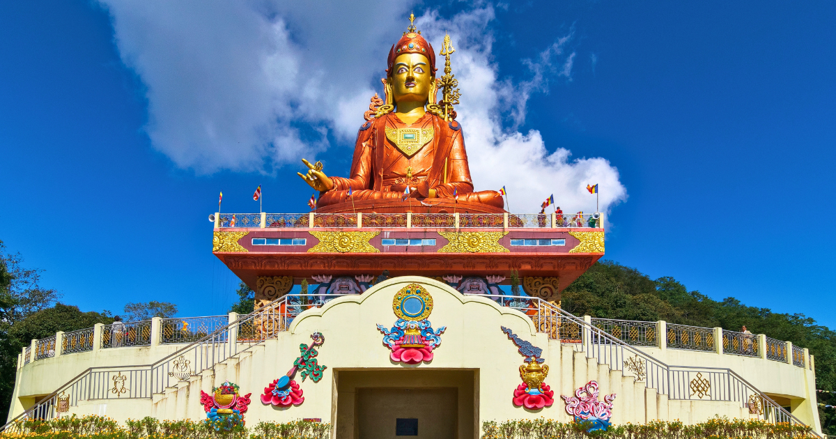
Samdruptse Hill, near Namchi, is home to the large Guru Padmasambhava statue and is often visited with Tarey Bhir.
Visiting Tarey Bhir with Remarkable East
Remarkable East designs small group journeys across Asia, with each departure limited to a maximum of 12 guests. Our itineraries are led by expert local guides and follow distinctive routes that reach beyond the standard tourist circuits, with carefully chosen accommodation throughout. Travellers interested in exploring South Sikkim can view our current small group departures or contact our team.