
Why Flores Is The Best Kept Secret In Indonesia
Indonesia stretches across thousands of islands, yet a trip to the country often begins and ends in Bali. Travelling further east brings Flores into the picture, where a visit to Komodo National Park can be combined with a journey through the island’s volcanic highlands. Boats leave from the port of Labuan Bajo for the nearby islands, while roads inland lead towards farming towns, mountain villages and crater lakes.
An overland journey takes travellers through farming regions where languages, house styles and weaving traditions change between communities. Around Bajawa, for example, Ngada villages have houses arranged around stone monuments that remain in use for ancestral rituals. Flores is often counted among hidden Indonesia destinations, but travelling across the island reveals how much lies beyond its better-known gateway to Komodo National Park.
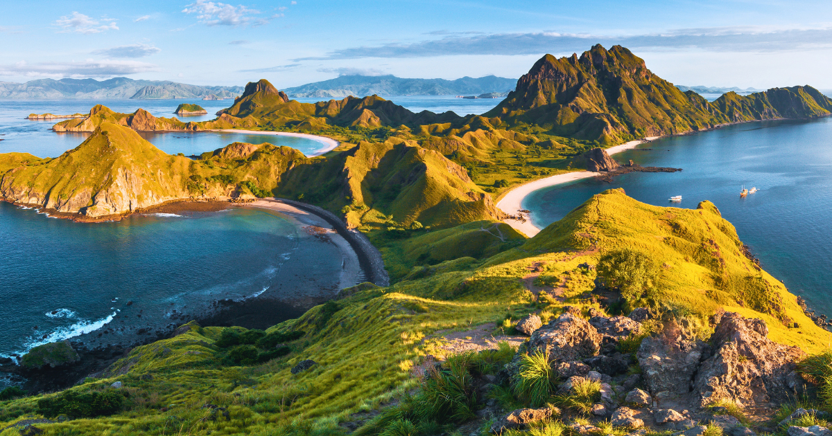
The islands off western Flores form part of Komodo National Park, where volcanic ridges rise between sheltered bays and coral-rich seas.
Where is Flores in Indonesia?
Flores belongs to the province of East Nusa Tenggara, also called Nusa Tenggara Timur. The Flores Sea borders its northern coast, while the Savu Sea lies to the south. Its mountainous interior separates the coastal settlements from highland towns such as Ruteng and Bajawa.
At its western end, the port of Labuan Bajo faces the islands of Komodo National Park, including Komodo and Rinca. Flores itself continues east through mountainous country to Larantuka, a coastal town near its eastern tip. Beyond Larantuka, smaller islands continue the chain towards the Alor Archipelago.
Why is Flores worth visiting?
Flores stands apart from many hidden Indonesia destinations because a journey across the island brings together volcanic landscapes and communities with distinct languages, customs and architectural traditions. The volcanic highlands offer walks, crater viewpoints and villages beneath mountain slopes, while visits to different communities reveal how family ties and ancestral beliefs shape life on the island.
Volcanic landscapes
Mountains are a constant presence on an inland journey through Flores. Roads climb over ridges and descend into cultivated valleys, with settlements spread across the slopes between them. Around Bajawa, Mount Inerie rises to 2,245 metres in a sharply defined cone. Bena is one of the villages below the volcano, where visitors can explore the settlement with Inerie rising behind its houses.
Further east, Kelimutu shows another side of the island’s geology. Three lakes fill separate craters near the summit, and their waters can look turquoise, green, brown or almost black. These colours change as conditions within the lakes change, influenced by volcanic gases entering from below. Even neighbouring lakes can look quite different because each has its own chemical conditions, making the view a visible sign of activity beneath the surface.
Distinct cultures across the island
The mountains also help explain Flores’ cultural variety. Steep ridges and valleys historically separated communities, allowing different languages and customs to develop within the same island. Those differences remain apparent on a journey across the island. The Manggarai around Ruteng, the Ngada around Bajawa and the Ende-Lio communities further east have their own traditions of weaving and house building, giving village visits a different focus in each region.
In Ngada communities, for example, family descent traditionally follows the female line, and inherited property passes through women. Family ancestry is also central to the village’s shrines, with each clan honouring male and female ancestors through a paired set of structures. At Bena, the male ancestors are represented by a ngadhu, a wooden post beneath a thatched roof. The corresponding bhaga resembles a miniature house and represents female ancestors.
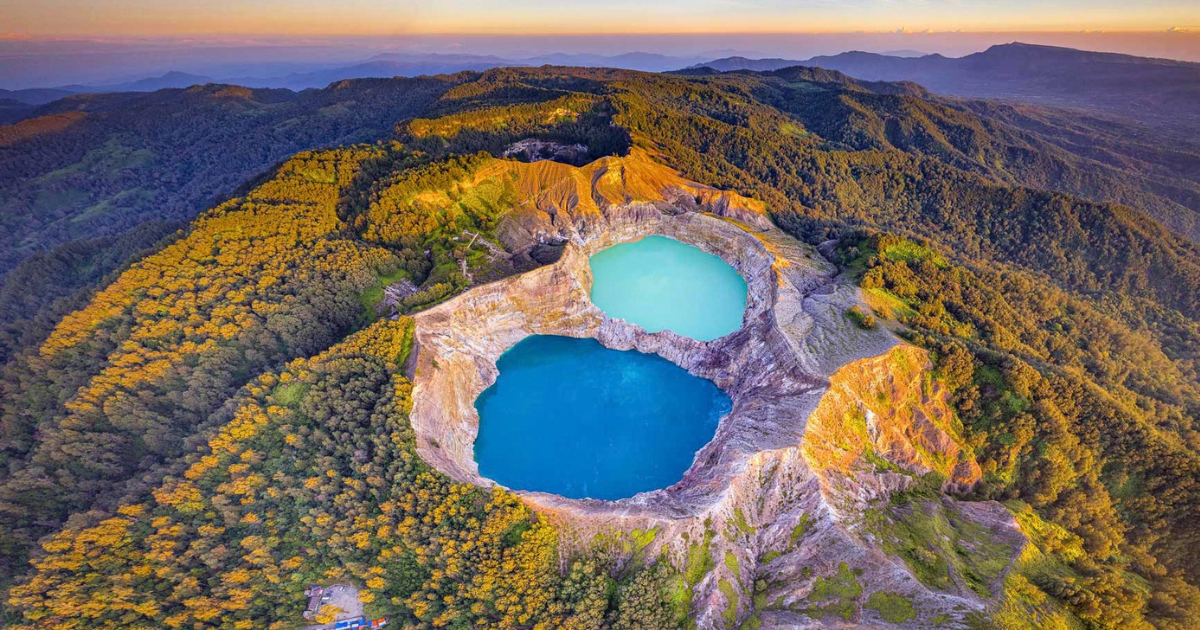
Kelimutu's neighbouring crater lakes can develop strikingly different colours as volcanic gases alter the chemical conditions of their waters.
What are the best places to visit in Flores?
Flores’ main places of interest stretch from Labuan Bajo on the western coast to Kelimutu’s crater lakes above Moni. Between them, the highlands around Ruteng and Bajawa are home to farming landscapes and villages shaped by local traditions, from the division of rice fields to the arrangement of houses around ancestral shrines.
Labuan Bajo
Labuan Bajo faces a sheltered bay dotted with boats and small islands. From its harbour, boats head towards Komodo National Park, where Komodo and Rinca are home to wild Komodo dragons. Coral reefs surround the islands, so the journey offshore brings both the animals and their neighbouring marine habitats within reach.
Back on Flores, Bukit Sylvia overlooks the bays and islands surrounding the harbour. Further inland, the sea has left traces in an unexpected place. Marine fossils lie embedded in the limestone walls of Batu Cermin cave, revealing that the rock formed underwater before becoming part of the land around Labuan Bajo.
Ruteng and the Manggarai highlands
Ruteng sits among hills and rice-growing valleys in the Manggarai region of western Flores. Nearby Ruteng Pu’u preserves the region’s traditional village layout, with tall thatched houses facing a communal courtyard. At its centre stands a stone platform called a compang, where offerings are made during community rituals.
The surrounding countryside also holds evidence of much earlier inhabitants. Excavations at Liang Bua cave in 2003 uncovered Homo floresiensis, an extinct human species nicknamed the “hobbit” because of its small stature. Alongside the human remains, researchers found stone tools and butchered bones of Stegodon, an extinct relative of elephants.
Cancar and the Lingko Rice Fields
Near Cancar, west of Ruteng, rice fields form enormous spider-web patterns across the valley. From the hillside above, individual plots can be seen radiating from central points and widening towards the outer edges. Several of these arrangements lie beside one another, each following the same principle of dividing land outwards from a shared centre.
The pattern comes from a Manggarai tradition of allocating communal farmland. A customary land leader used finger-width measurements near the centre to establish each family’s share, then extended the boundaries towards the field’s perimeter. Those narrow starting points produced the broad wedges visible today, giving the fields their distinctive shape.
Bajawa and Mount Inerie
Bajawa lies in the Ngada highlands, surrounded by cultivated valleys and villages beneath Mount Inerie. The volcano’s sharply pointed cone appears above fields and thatched roofs along the roads leading out of town. For a wider view, Wolobobo Hill overlooks the intervening valleys towards the mountain’s steep slopes.
The volcanic landscape continues beyond the viewpoints to hot springs around Bajawa. At Malanage, south of town, a hot stream meets a cold river. Their waters mix at the confluence, creating warmer and cooler patches within the same bathing area, where moving a short distance changes the temperature.
Moni and Kelimutu
Moni is a small village surrounded by farmland below Kelimutu, where three lakes occupy separate craters near the summit. From viewpoints above the steep crater walls, visitors can see how different the neighbouring waters appear. One lake may be turquoise or green while another looks brown or almost black.
In local Lio beliefs, each lake is a resting place for departed souls. These ancestors are honoured during the Pati Ka ritual, when customary leaders bring offerings of red rice, pork and other provisions to the mountain. The offerings are followed by a shared meal and gawi, a traditional dance in which participants hold hands in a circle and move in rhythmic steps.These gatherings bring surrounding communities together to honour their ancestors.
Bena
Bena occupies a narrow ridge near Bajawa, with rows of thatched houses arranged along stepped terraces beneath Mount Inerie. The homes face ancestral shrines and large ceremonial stones belonging to the village’s clans. Some stone structures mark burials, keeping the ancestors’ graves close to the families who continue to live here.
Family ceremonies have also left visible traces on the houses. Buffalo horns and pig jawbones displayed outside come from animals sacrificed during rituals and feasts. Kept after these gatherings, they record past ceremonies and signify family prosperity, giving the objects around each doorway a meaning beyond decoration.
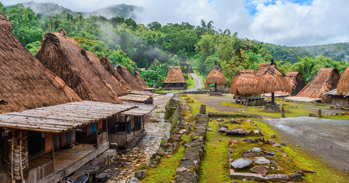
Bena is one of the Ngada villages near Bajawa, where traditional houses, ancestral shrines and ceremonial spaces remain central to the settlement.
What can travellers experience in Flores?
Travellers can meet village hosts, watch ikat being made, follow trails between highland settlements and explore the islands off the western coast. Local guides and craftspeople bring detail to these encounters, explaining the customs behind a welcome ceremony or the work involved in producing a patterned cloth.
Village visits and local guides
Village visits often begin with an introduction to the people responsible for welcoming guests. At Wae Rebo, visitors enter the main communal house for the Waelu’u ceremony, during which an elder seeks ancestral permission for their visit. The welcome takes place before guests explore the village, making its customs part of the encounter from the beginning.
Time with village hosts can continue over locally grown coffee or a shared meal, with a guide helping translate the conversation. Coffee is a main crop at Wae Rebo, so questions about planting, harvesting and selling the beans lead naturally into how families make their living in this mountain settlement.
Highland walks and village trails
Around Bajawa, a trail links Bena with Tololela through bamboo forest, with the option to continue towards Gurusina. Following this route on foot takes travellers away from the main road and through the countryside between settlements. A local guide can arrange village visits along the trail and introduce travellers to residents.
Visitors reach Wae Rebo on foot along a forest trail that climbs roughly 3.2 kilometres from the Pos 1 trailhead near Denge. The uphill walk takes around two to three hours, depending on pace and trail conditions. After several hours on the trail, the forest gives way to the village’s tall conical houses, enclosed by the surrounding mountains.
Boat trips, snorkelling and wildlife encounters
Boat trips from Labuan Bajo link ranger-led walks on Komodo or Rinca with beaches and snorkelling stops. Going ashore gives travellers the chance to observe Komodo dragons, while time in the water shows the reefs around the islands. The day moves between these habitats, with the boat carrying visitors from one landing or reef to the next.
At Karang Makassar, often called Manta Point, snorkellers may also encounter reef manta rays. These animals visit cleaning stations where small fish remove parasites and dead skin, sometimes circling or hovering above the reef while being cleaned. Sightings depend on conditions, with crews selecting suitable sites according to currents and the group’s swimming ability.
Ikat weaving and local markets
At Watublapi near Maumere, visitors can watch weavers prepare yarn for ikat cloth. Weavers tie sections of yarn to prevent them from absorbing dye, creating the pattern in the threads before weaving begins. They then arrange the dyed yarn on the loom, carefully aligning the coloured sections so the design takes shape as the cloth is woven.
Finished textiles are sold at Maumere’s Alok market, where local shoppers also wear ikat. Browsing the stalls allows time to compare motifs and colours from different weaving communities. Travellers can also ask where a piece was made and how it is worn to distinguish an everyday sarong from cloth intended for a particular ceremony.
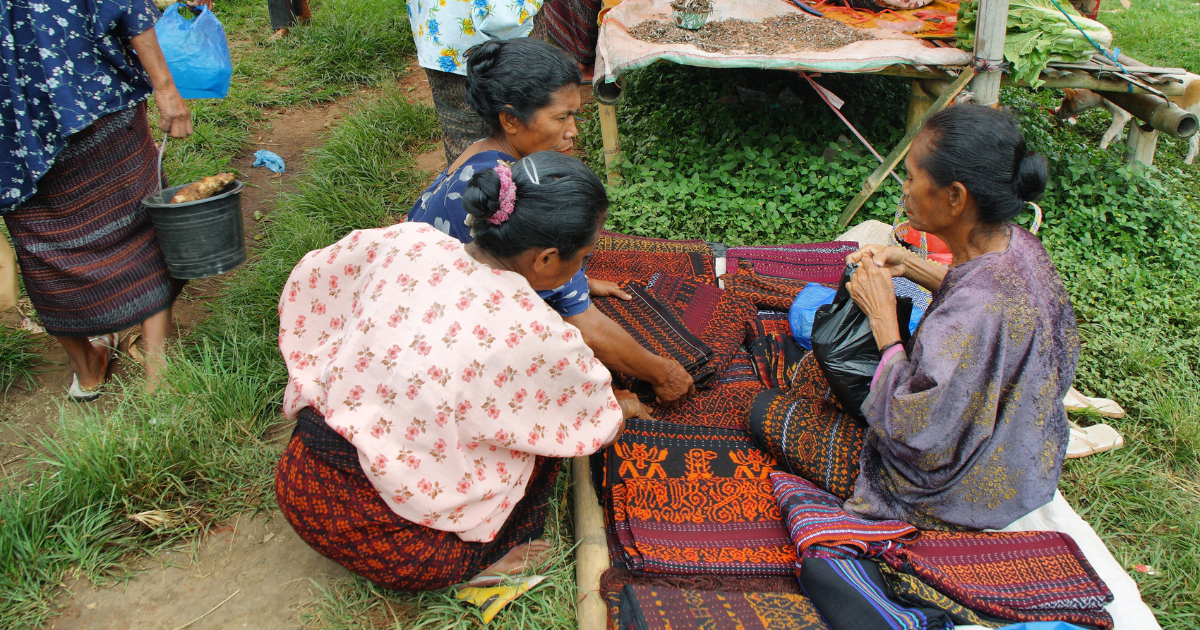
Ikat remains part of everyday and ceremonial life across Flores, with weaving communities producing their own combinations of motifs, colours and cloth styles.
What to know before planning a Flores trip
A Flores itinerary needs to account for mountain roads, regional flight connections and the time spent exploring between overnight stops. Choosing the arrival and departure airports first helps establish a workable route, while the season influences both inland walks and boat excursions around Komodo National Park.
Is Flores really off the beaten path?
Parts of Flores are, although Labuan Bajo is an established tourism centre with international flight connections, large beach resorts and organised boat excursions. A trip concentrated on the harbour town and Komodo National Park follows a well-developed visitor route. Travellers should expect company at popular island stops rather than assume that travelling east of Bali means leaving tourism behind.
Ruteng, Bajawa and Moni have accommodation and guides, but the smaller towns and countryside between them have fewer visitor services. Bena and Kelimutu are recognised attractions, so finding somewhere quieter often means allowing time beyond these main stops. For travellers seeking Indonesia beyond Bali, a longer overland journey allows time in smaller settlements between the main attractions.
Is Flores safe to visit after the 2026 earthquake?
Flores is welcoming travellers again as communities recover from the August 2026 earthquake. Tourism authorities have confirmed that Labuan Bajo’s airport and harbour are operating, boat trips to Komodo National Park have resumed, and inspected hotels are receiving guests. These services allow visitors to explore the western coast while recovery continues elsewhere on the island.
The earthquake caused extensive damage to homes, public buildings and roads, so an inland journey needs more careful planning. September 2026 reports listed Liang Bua and Ruteng Pu’u as temporarily closed, with restricted access at Kelimutu following landslides. Travellers should confirm road access, accommodation and attraction openings with their operator before finalising an itinerary, then check official updates close to departure.
How do travellers get to Flores?
Komodo Airport in Labuan Bajo is the main arrival point for western Flores, with direct flights from Bali and Jakarta. The flight from Bali takes roughly an hour to an hour and a half, making it a straightforward connection for travellers already in Indonesia. Direct services from Singapore also provide an option for reaching Labuan Bajo without passing through Bali.
An overland trip can begin in Labuan Bajo and finish in Ende or Maumere, or follow the route in reverse, avoiding a return drive across the island. The smaller airports have fewer domestic connections, so onward flights may involve a stop elsewhere in Indonesia. Flight availability helps determine the order of overnight stops. Where journeys involve separate tickets, an overnight connection provides more time between flights if a delay occurs.
When is the best time to visit Flores?
The dry season, broadly April to October, is the most practical period for combining an overland journey with Komodo boat trips. May to September falls comfortably within that window, although mountain areas can still receive rain and cloud. Clear weather on the coast does not guarantee an unobstructed view at Kelimutu, so two nights around Moni can leave room for another attempt if the first morning is clouded over.
Rain generally increases between November and March, with January and February among the wettest months. Trails can become slippery, road journeys may take longer, and rough seas can disrupt boat departures. An itinerary during these months needs spare time, particularly before an onward flight, rather than a sequence of excursions and transfers that depends on everything running to schedule.
How many days are needed to explore Flores?
For Komodo National Park and an overland journey through Ruteng, Bajawa and Moni, around 10 to 12 days provides a sensible planning allowance. This leaves several days for the coast and roughly a week inland, depending on the arrival and departure arrangements. Two-night stops around Bajawa and Moni give time for excursions without packing, driving and checking into another hotel every day.
Shorter crossings are possible, but much of each day can disappear into transfers. Flores tour itineraries often allow about five hours between Labuan Bajo and Ruteng, and around six hours between Bajawa and Moni. With only a week available, reducing the geographical scope leaves more time for the places included. Wae Rebo also needs a separate allowance for the road approach, uphill walk and return journey as it cannot be treated as a quick roadside stop.
How do travellers get around Flores?
A private car with a driver allows stops at villages and viewpoints between overnight stays. The Trans-Flores road winds over ridges and through valleys, so short distances on a map can take longer to cover than expected. Transport and guiding may be separate services, so a driver’s role does not necessarily include explaining village customs or interpreting conversations with residents.
Shared shuttles and local buses, including services such as Gunung Mas, connect the main towns. Journeys to villages, trailheads and Kelimutu may require separate transport. For private vehicles, quotations need to specify whether fuel and the driver’s overnight expenses are included. A trip ending in a different town may also incur a charge for returning the vehicle to its starting point.
What are the accommodation options?
Accommodation varies between the coast and the interior. Labuan Bajo has beachfront resorts and larger hotels, while an overland journey includes smaller hotels and lodges in the highland towns. Properties around Bajawa and Moni are generally simpler, so travellers combining the coast with the interior can expect facilities to change along the route.
Location is an important consideration when choosing a highland stay. Accommodation around Moni provides a base for Kelimutu visits, while Bajawa allows time for nearby villages and hot springs. For overnight boat trips in Komodo National Park, the cabin arrangement, bathroom facilities and number of passengers are practical details to establish before booking.
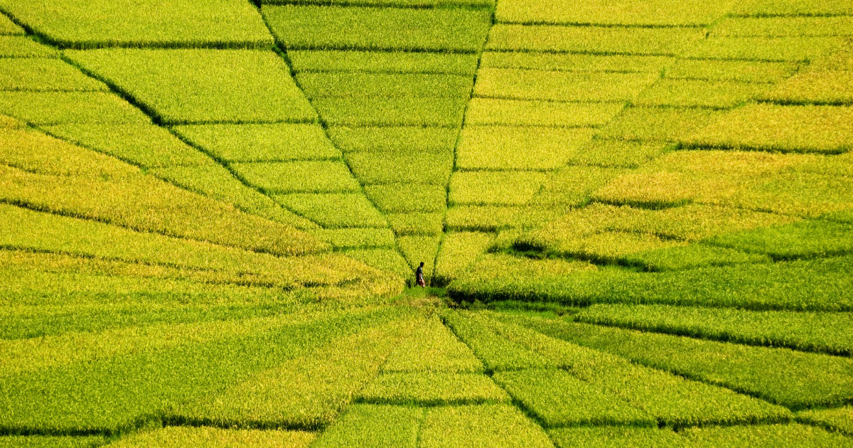
The spider-web pattern of Flores’ lingko fields comes from the Manggarai tradition of dividing communal farmland into family plots that widen outwards from a shared centre.
Explore Flores with Remarkable East
Remarkable East specialises in small group journeys across Asia, with a maximum of 12 guests on each departure. Our Heartlands of Flores tour travels through Flores’ highlands to Kelimutu’s crater lakes and Ngada villages, then continues with three days sailing through Komodo National Park aboard a traditional phinisi boat. Contact our team to discuss the itinerary and upcoming departures.