
Why The Korean DMZ IS More Than A Line On The Map
The Korean Peninsula stretches south from mainland Asia between the Yellow Sea and the East Sea. Across its river valleys and mountain ranges, the Korean Demilitarized Zone (the Korean DM) separates North and South Korea. Although the two countries share a language and centuries of cultural heritage, the border restricts movement between them, separating families as well as territory.
Visiting the Korean DMZ helps explain how this division developed and affected communities. Museums trace the separation after World War II and the Korean War that followed, while former railway stations mark routes interrupted by the border. At the observatories, visitors can look towards North Korean towns and farmland, seeing places that remain geographically close but largely inaccessible from the south.
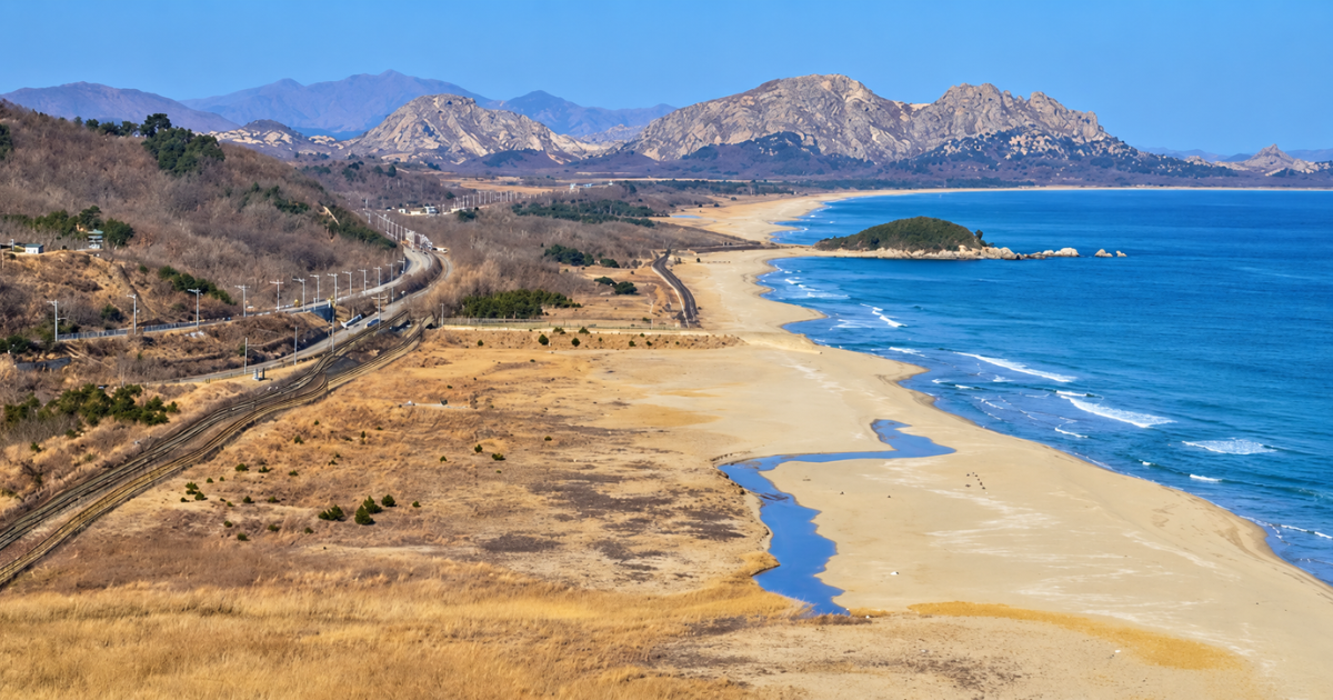
Goseong Unification Observatory overlooks the eastern end of the DMZ, where the military boundary meets the East Sea. South Korea’s coastal railway and checkpoints lie below, while Haegeumgang’s coastal rocks and the peaks of Mount Geumgang are visible across the border in North Korea.
What is the Korean DMZ?
The Korean DMZ is a buffer zone created to keep the opposing forces of North and South Korea apart. Around 250km long and 4km wide, it stretches across the peninsula from the Imjin River area in the west to Goseong on the east coast. Paju, north of Seoul, lies near its western section, while Cheorwon and Goseong provide access to different parts of the border region.
The zone took shape when the 1953 armistice halted fighting in the Korean War. The agreement established a Military Demarcation Line along the positions held by the two sides, then required their forces to withdraw 2km in each direction. The land between them became the DMZ, giving the ceasefire a physical buffer.
The armistice was intended to hold while a peace settlement was negotiated, but no final settlement followed. The DMZ continues to keep the two sides apart, with military controls governing access. Within it, the Joint Security Area at Panmunjom was established as a place for representatives of the opposing sides to meet. Its conference buildings have hosted negotiations about the armistice, making dialogue part of the Korean border history alongside division.
Why was Korea divided?
Korea’s division began as a temporary arrangement between the United States and the Soviet Union at the end of World War II. Their growing rivalry, alongside competing political movements within Korea, prevented agreement on a single government. Separate states emerged, and the Korean War later established the boundary followed by today’s DMZ.
The division of the peninsula in 1945
When Japan surrendered in August 1945, its colonial rule over Korea ended, leaving the peninsula’s future government undecided. The United States and the Soviet Union agreed to oversee the surrender of Japanese forces on either side of the 38th parallel, a line of latitude crossing Korea. Soviet troops took responsibility in the north, while American troops administered the south.
What began as a temporary arrangement became harder to reverse as the United States and the Soviet Union supported different visions for Korea’s future. Each backed political leaders aligned with its interests, and growing Cold War rivalry complicated negotiations over a unified government. Separate political institutions developed within the occupation zones, laying the foundations for two states.
Separate governments and the Korean War
By 1948, the occupation zones had become two states. The Republic of Korea formed in the south under Syngman Rhee with American support, while the Soviet-backed Democratic People’s Republic of Korea emerged in the north under Kim Il Sung. Both claimed authority over the whole peninsula, leaving the question of who would govern a reunited Korea unresolved.
On 25 June 1950, North Korean forces invaded the South in an attempt to reunify the country under their control. A United States-led United Nations force intervened to support the South, while China later entered the war on the North’s side. As the fighting moved back and forth, communities were displaced and families separated. By 1951, the front had largely stabilised near the original dividing line, but neither side had achieved reunification.
The 1953 armistice and the creation of the DMZ
With neither side achieving a decisive victory, negotiations began in July 1951, although fighting continued while the terms were debated. Reaching an agreement took two years because of disagreements over the return of prisoners of war. An armistice was finally signed on 27 July 1953 by representatives of the United Nations Command, the North Korean army and the Chinese People’s Volunteers.
The agreement used the armies’ positions near the end of the war to establish the military boundary around which the DMZ was created. Unlike the straight line of the 38th parallel, this boundary followed the wartime front across hills and valleys. The new boundary left some towns and districts on the opposite side from where they had been before the war, turning the military stalemate into the geography of the border today.
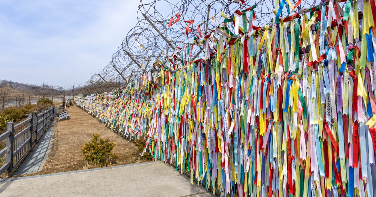
Visitors tie colorful ribbons to the fence to express hopes for peace and the eventual reunification of the Korean Peninsula. Imjingak Park sits near the banks of the Imjin River, close to the Freedom Bridge where prisoners of war returned.
What can visitors see at the Korean DMZ?
Visitors can explore former railway stations, descend into an infiltration tunnel and look across the border from designated observatories. Museums and memorials add the stories behind these places, covering military history, separated families and hopes for reunification. The sites are spread across Paju, Cheorwon and Goseong, so the route chosen determines which are included.
Imjingak Peace Park
Imjingak was established beside the Imjin River in Paju in 1972 for people unable to return to their hometowns in North Korea. That purpose is still reflected in the Mangbaedan altar, where displaced families gather during Seollal, the Lunar New Year, and Chuseok, the autumn harvest festival. These holidays traditionally involve remembering ancestors and visiting family, so the altar provides a place to perform those observances while facing towards homes across the border.
Nearby, a steam locomotive from Jangdan Station preserves evidence of the railway’s wartime role. It carried military supplies along the Gyeongui Line before being damaged during the conflict, and its battered body is now displayed at Imjingak. The adjacent Freedom Bridge belongs to the next chapter of that history, when prisoners released after the 1953 armistice crossed back into the South.
The Third Infiltration Tunnel
Near Panmunjom, the Third Infiltration Tunnel runs through bedrock beneath the military boundary towards South Korea. North Korea excavated the passage to move troops past the defences above ground, but South Korean forces discovered it in 1978 before it could serve that purpose. It was the third of four infiltration tunnels found along the border, showing how military preparations continued after the 1953 armistice.
Visitors can enter a section on the South Korean side, descending to a passage around 73m below ground. Although the tunnel extends for roughly 1.6km, only part is open for visits, and the route stops before the Military Demarcation Line. Inside, the passage is approximately two metres wide, with low sections that require taller visitors to bend as they walk. Its dimensions reflect its intended use as a concealed military route.
Dora Observatory
The Dora Observatory overlooks the western DMZ from Paju, where fields and settlements occupy the land around the military boundary. One of the places visible is Daeseong-dong, the only South Korean village entirely within the DMZ. Residents continue to live and farm here under special access controls, making the village an important part of the view. The buffer zone contains homes and cultivated land as well as military facilities.
Farther north lies Kaesong, the former capital of the medieval Goryeo kingdom. Its presence beyond the border places a city central to Korea’s shared history within sight of visitors in the South. A guide can help locate Kaesong and distinguish it from the villages closer to the observatory, explaining which settlements lie inside the DMZ and which stand beyond its northern edge.
Cheorwon Peace Observatory
Cheorwon Peace Observatory overlooks the Cheorwon Plain and the central section of the DMZ towards North Korea. A monorail carries visitors uphill to the building, where the viewing floor provides an outlook across fields, hills and the border area. An exhibition hall below displays photographs of checkpoints, military facilities and the nearby Second Infiltration Tunnel, adding detail about locations that are harder to distinguish from a distance.
The view also includes the area where Gung Ye established his capital in the early tenth century, when he ruled the kingdom later known as Taebong. That archaeological site now lies within the DMZ, placing remains of an earlier Korean state inside the modern buffer zone. Visitors look towards the site rather than walking among its ruins, with explanations at the observatory helping locate it within the surrounding plain.
Woljeong-ri Station
Woljeong-ri Station was once a small stop on the Gyeongwon Line, which linked Seoul with the east coast port of Wonsan through Cheorwon. Before division and war interrupted the route, trains connected places that now sit on opposite sides of the border. Communities once linked by a train journey became separated by military restrictions.
The visitor site preserves that interrupted connection through a station building and the wreckage of a train damaged during the Korean War. Beside the remains, a sign commonly translated as “The iron horse wants to run again” expresses the hope of reopening the line. Knowing its former route makes the message more specific. It refers to a railway that once carried people between the capital and the coast, but now stops short of completing that connection.
Goseong Unification Observatory
Goseong Unification Observatory looks north from near the eastern end of the DMZ, where the border meets the coast. Unlike the observatories around Paju, the Goseong DMZ observatory offers a coastal view, following the shoreline towards Haegeumgang and the mountains around Geumgangsan.
The original observatory opened in 1984, and a 34-metre viewing tower was added in 2018 to provide a higher vantage point. When visibility allows, visitors can see the shoreline, offshore rocks and mountain slopes together from the tower. The complex’s Korean War exhibition hall explains the history of the eastern border, giving visitors background to the area before or after spending time at the viewing windows.
Goseong DMZ Museum
Near the Unification Observatory, Goseong DMZ Museum preserves objects and accounts associated with the border. Opened in 2009, its exhibitions follow the Korean War, the creation of the DMZ and the decades of division that followed. Displays about communities within the zone extend this history beyond military events to the people who continued living alongside the boundary.
Outside, visitors can walk beside sections of fencing transferred from the DMZ’s southern boundary and examine equipment once used to send political messages across it. Loudspeakers broadcast those messages, while an illuminated signboard displayed text towards North Korea. Other galleries examine the wildlife habitats preserved partly through restrictions on access and development.
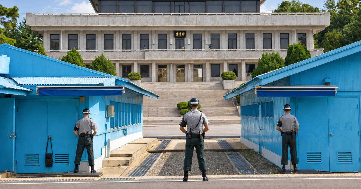
Dora Observatory is one of the main stops on the Paju DMZ route, with views across the western border region towards North Korea.
Can travellers visit the Korean DMZ?
Yes, travellers can visit designated sites in and around the Korean DMZ from South Korea. Access depends on the location. Imjingak’s main park and memorials can be explored independently, while attractions beyond military checkpoints require registration and permission to enter. To reach the Third Infiltration Tunnel and Dora Observatory , travellers can join an organised tour, either departing from Seoul or through the local programme at Imjingak.
Farther east, the Goseong route allows visitors to travel in their own vehicle after completing the entry process. The first stop is the Unification and Security Park, where visitors register and attend a short briefing before driving through the checkpoint towards the observatory and museum. These arrangements allow access to specific attractions within the controlled area, with visitors following the approved route between them.
What to know before visiting the Korean DMZ
A Korean DMZ visit needs a little more preparation than most sightseeing trips. The chosen route determines how long the journey takes and which entry arrangements apply, while the season can make a considerable difference to the views from the observatories.
Is the Korean DMZ still active?
Yes, the Korean DMZ remains a working military buffer, with personnel monitoring the boundary and controlling access. Although museums and observatories welcome visitors, they operate within an area where the 1953 armistice is still enforced. The checkpoints passed along the way are part of that continuing role.
Permission to visit also depends on conditions that day, so a booked excursion can still be changed or cancelled. Once admitted, travellers must remain on the approved route and follow the rules for that programme. In Paju, those rules currently include a ban on photography and filming throughout the DMZ Peace Tour route.
How far is the DMZ from Seoul?
Imjingak, the starting point for the Paju DMZ programme, lies approximately 56km from Seoul City Hall. Visitors then continue through military checkpoints towards the Third Tunnel and Dora Observatory. The local DMZ Peace Tour takes around three hours, so an excursion from Seoul also needs to allow for the outward journey, registration and return transfer.
Cheorwon and Goseong are farther east and require separate itineraries. Goseong is particularly suited to a stay around Sokcho or a journey along the east coast, where the observatory and museum can form part of a wider regional visit. These eastern sites are too far from Paju to combine comfortably into the same sightseeing day.
When is the best time to visit the Korean DMZ?
Spring (March to May) and autumn (September to November) generally offer the most comfortable temperatures for a DMZ visit. These seasons suit itineraries with walking stops at Imjingak and time at the observatories, though early spring and late autumn can still be cold. Summer (June to August) is hotter, more humid and wetter, while winter (December to February) requires warm clothing for outdoor stops.
For the views into North Korea, visibility matters more than temperature. Rain, mist and haze can obscure Kaesong and the surrounding mountains even on a mild day. Checking the forecast can help when choosing between available tour dates, but no season guarantees an unobstructed view.
How much does it cost to visit the DMZ?
Group departures from Seoul include options at around ₩70,000 to ₩80,000 (approximately AUD $74 to $84) per adultcovering return transport, a guide and admission to the included stops. Meals and optional activities may cost extra. Some operators collect guests from hotels, while others depart from central meeting points that travellers must reach independently.
For those arranging their own journey to Imjingak, Paju’s local DMZ Peace Tour lists adult fares of ₩9,200 (around AUD $10) with walking access to the tunnel or ₩12,200 (around AUD $13) with monorail access. These fares exclude transport from Seoul and a dedicated guide, so they cover less than a guided city departure. Private journeys are quoted separately according to the number of travellers, vehicle and guiding arrangements.
What should visitors bring and prepare for?
International visitors need their original passports for entry checks on the Paju route, as photographs and photocopies are not accepted. Comfortable walking shoes are useful at the attractions and particularly on the tunnel’s entrance slope. Water and an extra layer are also worth carrying for a day that moves between coach journeys, indoor displays and outdoor stops.
The tunnel walk begins with a steep descent, followed by a low passage where taller visitors need to bend. The return follows the same route uphill. Monorail access avoids the entrance slope but still requires walking underground, so the confined space remains a consideration. Some operators allow visitors to wait above ground while the group descends. Anyone considering this option needs to confirm it with the operator before booking.
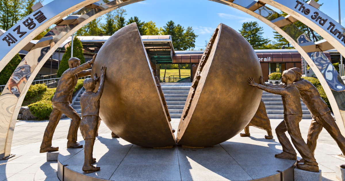
The Third Infiltration Tunnel was dug by North Korea beneath the military boundary to move troops into the South. The sculpture at its entrance expresses the hope of reuniting the divided peninsula.
Explore the Korean DMZ with Asia Unbound
Asia Unbound specialises in private, custom-made journeys across Asia, with local guides and accommodation chosen to suit each traveller’s interests and pace.
Our Classic South Korea itinerary includes Goseong Unification Observatory and the DMZ Museum on the journey from Seoul to Seoraksan National Park. The itinerary can be adapted to the time available and the places of greatest interest. Explore our South Korea tours or contact our team to begin planning a private journey that includes the Korean DMZ.